Modul:Imagemap/bs
Beispiel
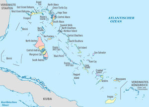
Diese Imagemap dient der Positionskarte von Bahamas mit seinen administrativen Untereinheiten, zum Beispiel für den Einsatz in der Quickbar.
Quelle: Template:Bahamas imagemap
Verwendung
{{Imagemap}}
Um eine Imagemap zu erzeugen kannst du folgende Syntax verwenden:
- Syntax:
{{Imagemap|image=Bildatei|imagemap=imagemap|size=Größe|desc=Beschreibung|align=Ausrichtung}}
Parameter:
|image=Name der Bilddatei ohne Wikisyntax (keine eckige Klammern)|size=Breite der Bilddatei. Die Angabe ist optional. Standard sind 200 Pixel.|imagemap=Name der Imagemap. Sie muss im Namensraum Modul als Unterseite des Moduls Imagemap abgelegt sein (Modul:Imagemap/<Name>). Hinweis: Die Länderkürzel (Top-Level-Domain) sollten den Imagemaps für die Länder-Positionskarten vorbehalten bleiben.|desc=Lage des Info-Buttons welcher zur Bilddatei verlinkt. Die Angabe ist optional. Mögliche Werte sind: top-right, bottom-right, bottom-left, top-left, none. Standardmäßig wird der Button deaktiviert (none).|align=Ausrichtung der Imagemap. Die Angabe ist optional. Mögliche Werte sind: left, center, right. Standardeinstellung ist links (left).
Das Beispiel rechts bzw. unten wird folgendermaßen erzeugt:
{{Imagemap| image = File:Bahamas, administrative divisions - de - colored.svg | imagemap = bs | size = 300px }}
{{Quickbar Region}}
Für die Anwendung in der Quickbar für Regionen muss lediglich ein zusätzlicher Parameter zur Lagekarte gesetzt werden.
|Lagekarte=erzeugt die Karte (manuelle Angabe oder Einbindung durch Wikidata)|Imagemap=bserzeugt die passende Imagemap.
Karten
Folgende Karten können ohne Anpassungen direkt genutzt werden:
- Die in den Quickbars beliebten Locator maps der einzelnen Länder.
- Farbige administrative Karten in der allgemeinen oder deutschen Version (wie hier rechts im Beispiel)
Verfügbare Länder-Imagemaps
Hinweise
- Die obige Dokumentation wurde aus der Seite Modul:Imagemap/bs/Doku eingefügt. (bearbeiten | Versionsgeschichte) Die Kategorien für dieses Modul sollten in der Dokumentation eingetragen werden. Die Interwiki-Links sollten auf Wikidata eingepflegt werden.
- Liste der Unterseiten
imagemap = {
'poly 4 660 198 753 362 800 457 837 613 906 694 973 741 1017 826 1034 878 1068 895 1093 892 1120 240 1122 120 1018 26 948 0 938 [[Kuba]]',
'poly 1277 990 1296 925 1336 876 1370 846 1427 847 1509 891 1548 953 1535 1067 1477 1111 [[Turks- und Caicosinseln]]',
'poly 67 0 116 105 124 191 109 293 83 378 55 418 15 443 3 441 0 2 [[Vereinigte Staaten]]',

'poly 1066 941 1065 1104 1247 1100 1242 954 [[Iangua]]',
'poly 1212 788 1094 918 1252 920 1347 822 [[Mayaguana]]',
'poly 976 884 1089 759 1128 760 1194 784 1167 816 1041 954 [[Acklins]]',
'poly 970 794 967 755 985 735 1087 692 1140 719 1124 758 1080 759 995 858 [[Crooked Island]]',
'poly 842 587 947 690 1011 654 934 586 [[Rum Cay]]',
'poly 944 530 937 588 1003 643 1038 527 [[San Salvador]]',
'poly 846 610 816 641 847 670 807 719 949 824 968 705 [[Long Island]]',
'poly 785 721 742 742 733 845 764 907 814 919 831 877 818 744 [[Ragged Island]]',
'poly 650 568 685 543 710 572 678 597 [[Black Point]]',
'poly 579 427 582 535 781 716 804 714 844 672 738 567 625 424 [[Exuma and Cays]]',
'poly 709 507 784 431 859 454 914 496 936 568 932 590 804 584 [[Cat Island]]',
'poly 654 418 759 418 755 436 748 457 705 502 649 430 [[South Eleuthera]]',
'poly 451 367 483 426 543 427 593 426 587 389 560 373 [[New Providence]]',
'poly 317 244 444 368 544 353 440 233 [[Berry Islands]]',
'poly 315 158 318 177 340 168 329 149 [[Freeport]]',
'poly 342 100 363 159 337 164 332 152 313 157 318 176 287 173 256 138 252 120 [[West Grand Bahama]]',
'poly 215 229 168 321 226 370 148 569 50 529 20 566 24 645 137 669 211 692 229 588 225 575 126 552 227 367 288 376 289 363 328 337 361 296 258 199 [[Bimini]]',
'poly 347 103 370 162 414 154 445 177 469 160 475 132 467 117 399 117 378 96 [[East Grand Bahama]]',
'poly 377 27 359 56 397 116 446 50 [[Grand Cay]]',
'poly 471 178 476 220 519 222 513 176 [[Moores Island]]',
'poly 640 400 706 315 753 372 766 401 748 416 666 413 [[Central Eleuthera]]',
'poly 609 307 610 337 622 333 622 307 [[Spanish Wells]]',
'poly 649 321 636 324 638 337 662 337 656 322 [[Harbour Island]]',
'poly 591 320 602 316 609 322 616 334 623 332 622 317 629 316 638 317 638 328 638 338 655 341 656 341 673 343 677 346 679 351 662 371 653 360 639 351 621 352 617 358 613 367 604 368 596 364 595 355 611 346 [[North Eleuthera]]',
'poly 554 109 551 132 566 147 582 159 584 174 594 193 610 179 593 142 589 121 [[Hope Town]]',
'poly 539 107 523 117 531 127 539 128 547 118 548 107 [[Green Turtle Cay]]',
'poly 401 110 453 49 496 73 513 90 530 110 522 115 523 123 531 126 543 129 545 124 551 130 554 135 527 138 503 138 481 133 471 120 465 115 404 116 [[North Abaco]]',
'poly 502 137 506 162 512 175 525 187 581 184 579 156 558 139 [[Central Abaco]]',
'poly 529 182 525 206 536 216 528 232 503 225 489 232 501 256 529 271 549 284 564 273 568 244 568 220 587 208 594 193 586 185 [[South Abaco]]',
'poly 400 348 443 398 463 447 471 472 457 477 419 482 403 498 392 512 380 518 339 500 327 484 318 462 366 408 371 369 [[North Andros]]',
'poly 382 519 410 486 459 478 481 476 489 490 491 515 484 524 452 545 436 554 409 559 [[Central Andros]]',
'poly 412 564 445 549 485 517 499 523 492 536 475 559 471 571 455 577 430 576 423 576 [[Mangrove Cay]]',
'poly 429 579 468 575 478 552 485 528 519 561 520 606 513 627 472 640 455 639 429 586 [[South Andros]]',
}

return imagemap