Datei:Sevastopol, Ukraine.jpg

Originaldatei (1.080 × 1.440 Pixel, Dateigröße: 455 KB, MIME-Typ: image/jpeg)
Beschreibung
| Beschreibung |
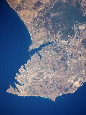
English: This satellite image highlights the jagged coastline of the southern Crimean Peninsula and the various docking areas of Sevastopol. The urban area is light grey, and it is bounded to the north and west by the Black Sea, to the south by vegetated (light green) and fallow (tan) agricultural fields, and to the east by the city of Inkerman and vegetated uplands (deep green). The city of Balaklava, to the south, houses another relic of the Cold War—an underground Soviet submarine base that is now open to the public as a monument. The Chernaya River issues into the Black Sea near Inkerman, flowing into the Sevastopol Inlet to the west.
|
||||||||||||||||||||||||||||||||||||||||||||||||||||||
| Datum | |||||||||||||||||||||||||||||||||||||||||||||||||||||||
| Quelle | NASA Earth Observatory | ||||||||||||||||||||||||||||||||||||||||||||||||||||||
| Urheber | This image was taken by the Nasa Expedition 20 crew. | ||||||||||||||||||||||||||||||||||||||||||||||||||||||
Image acquired with a Nikon D3 digital camera fitted with a 400 mm lens, and is provided by the ISS Crew Earth Observations experiment and Image Science & Analysis Laboratory, Johnson Space Centre. Instrument: ISS - Digital Camera.
Lizenz
| Diese Datei ist gemeinfrei (public domain), da sie von der NASA erstellt worden ist. Die NASA-Urheberrechtsrichtlinie besagt, dass „NASA-Material nicht durch Urheberrecht geschützt ist, wenn es nicht anders angegeben ist“. (NASA-Urheberrechtsrichtlinie-Seite oder JPL Image Use Policy). | ||
 |
Warnung:
|
| Bildnotizen | Diese Datei ist annotiert: Betrachte diese auf Commons. |
Dateiversionen
Klicke auf einen Zeitpunkt, um diese Version zu laden.
| Version vom | Vorschaubild | Maße | Benutzer | Kommentar | |
|---|---|---|---|---|---|
| aktuell | 13:44, 20. Jan. 2015 | | 1.080 × 1.440 (455 KB) | Anonimski | Rotated to proper map orientation |
| 11:27, 24. Aug. 2009 |  | 1.440 × 1.080 (532 KB) | Originalwana | {{Information |Description={{en|1=This astronaut photograph highlights the jagged coastline of the southern Crimean Peninsula and the various docking areas of Sevastopol. The urban area is light grey, and it is bounded to the north and west by the Black S |
Dateiverwendung
Die folgende Seite verwendet diese Datei:
Globale Dateiverwendung
Die nachfolgenden anderen Wikis verwenden diese Datei:
- Verwendung auf af.wikipedia.org
- Verwendung auf ast.wikipedia.org
- Verwendung auf azb.wikipedia.org
- Verwendung auf az.wikipedia.org
- Verwendung auf bn.wikipedia.org
- Verwendung auf ca.wikipedia.org
- Verwendung auf de.wikipedia.org
- Verwendung auf en.wikipedia.org
- Verwendung auf es.wikipedia.org
- Verwendung auf fa.wikipedia.org
- Verwendung auf is.wikipedia.org
- Verwendung auf it.wikipedia.org
- Verwendung auf mn.wikipedia.org
- Verwendung auf pl.wikipedia.org
- Verwendung auf pl.wiktionary.org
- Verwendung auf ru.wikipedia.org
- Verwendung auf uk.wikipedia.org
- Verwendung auf uk.wikivoyage.org
- Verwendung auf www.wikidata.org
- Verwendung auf zh.wikipedia.org